1. Welcome to Tacoma World!

    You are currently viewing as a guest! To get full-access, you need to register for a FREE account.

    As a registered member, you’ll be able to:
    • Participate in all Tacoma discussion topics
    • Communicate privately with other Tacoma owners from around the world
    • Post your own photos in our Members Gallery
    • Access all special features of the site
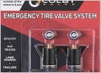
Battle of the Apps: Gaia GPS vs AllTrails vs ViewFinder...

Discussion in 'Off-Roading & Trails' started by COTaco4lyphe, Oct 1, 2019.

  1. Oct 1, 2019 at 11:14 AM
    #1
    COTaco4lyphe

    COTaco4lyphe [OP] Well-Known Member

    Joined:
    Nov 24, 2018
    Member:
    #273664
    Messages:
    80
    Gender:
    Male
    This applies to off-roading for sure but also in general (I use Gaia for fishing/hunting, knowing where private/public prop is for example).

    Anyone have a preferred app? I seem to find Gaia the best overall but certainly a learning curve.
     
  2. Oct 1, 2019 at 11:51 AM
    #2
    PcBuilder14

    PcBuilder14 Well-Known Member

    Joined:
    Jun 19, 2011
    Member:
    #58522
    Messages:
    23,311
    Gender:
    Male
    First Name:
    Brent
    Nor Cal
    Vehicle:
    2018 Tacoma TRD Off Road 4x4
    I use Gaia for everything other than researching hiking trails. For hiking I use AllTrails.
     
    In&out and COTaco4lyphe[OP] like this.
  3. Oct 1, 2019 at 11:56 AM
    #3
    turbodb

    turbodb AdventureTaco

    Joined:
    Feb 9, 2016
    Member:
    #177696
    Messages:
    8,445
    Gender:
    Male
    First Name:
    Dan
    PNW
    Vehicle:
    2000 Tacoma Xcab 4x4 SR5 V6 TRD
    AdventureTaco
    My go-to app at the moment is Backcountry Navigator Pro (on Android). My hope in the future is that Backcountry Navigator XE (Android + iOS) evolves into it's replacement.

    While BCN Pro isn't the easiest to learn out the gate, it seems to have the most power/flexibility to me, and once you learn it, the controls are easy enough to do (unburied) while driving, which is nice.

    I wrote up a three-part series on route planning where I use Google Earth, Maps, and BCN. Feel free to check it out and ask questions if you have any...

    [​IMG]
     
    jbrandt and Elkyri like this.
  4. Oct 1, 2019 at 12:01 PM
    #4
    COTaco4lyphe

    COTaco4lyphe [OP] Well-Known Member

    Joined:
    Nov 24, 2018
    Member:
    #273664
    Messages:
    80
    Gender:
    Male
    Oh that is awesome, even though it seems that is not on iOS the other info on there regarding google maps etc is great!
     
  5. Oct 1, 2019 at 1:59 PM
    #5
    Hyland33

    Hyland33 Well-Known Member

    Joined:
    Aug 8, 2017
    Member:
    #226316
    Messages:
    581
    Gender:
    Male
    First Name:
    Andrew
    Leicester, MA
    Vehicle:
    2015 Tacoma TRD Offroad
    Gaia is my go to
     
  6. Oct 1, 2019 at 2:50 PM
    #6
    jbrandt

    jbrandt Made you look

    Joined:
    Feb 12, 2011
    Member:
    #51038
    Messages:
    17,612
    Gender:
    Male
    First Name:
    Justin
    El Dorado, CA (NOT El Dorado Hills)
    Vehicle:
    '04 TRD Tacoma 4x4 DC
    Kings, J59's Total Chaos UCAs Custom skids Sticker mod
  7. Oct 2, 2019 at 10:55 AM
    #7
    COTaco4lyphe

    COTaco4lyphe [OP] Well-Known Member

    Joined:
    Nov 24, 2018
    Member:
    #273664
    Messages:
    80
    Gender:
    Male
    Thanks! Great info in those for sure, was reading some but some were a bit dated (or really geared for android folks) as well...or a lot has changed I would say in the app realm over a few years. Anyway, seems Gaia is the typical consensus for iOS.

    Actually, I will add another question out there for Gaia users:

    How have you found the best way to use it in certain scenarios (off-road/hiking/hunting or fishing/biking/exploring)? There are so many maps, map options, what to download for offline use in each of the above situations, it really can be overwhelming.
     
  8. Oct 2, 2019 at 11:24 AM
    #8
    Dor

    Dor Well-Known Member

    Joined:
    Apr 21, 2018
    Member:
    #251278
    Messages:
    352
    Gender:
    Male
    First Name:
    James
    Vehicle:
    '18 MB ACLB TRD-OR
    I use Gaia pretty obsessively, both for route planning and also for navigating on the trail. Warning, novel incoming:

    For route planning, my layers look something like:
    upload_2019-10-2_11-16-38.jpg
    (I've manually added Google satellite and map layers)

    Depending on the kind of terrain I'm in I'll alter the opacities as necessary the logic is:
    • Google Maps as a base layer to help orient myself vs cities/towns/highways in the area of the trail
    • Gaia topo to give me a topo layer outside of USFS land
    • Google Sat Hybrid (which has both sat and labels for roads/towns/etc) for a high quality satellite layer - I prefer to use this when route planning so I can see what the terrain looks like, but not always possible in heavily forested areas.
    • The USFS 2016 map is amazing when on USFS land, and it becomes my main layer when satellite is too obscured
    • The USFS Roads and Trails and MVUM layers help me understand which roads from the USFS maps are legal to drive on, and help outline the shape of roads on the satellite layer.
    All of that is route planning. When it comes to what I download to actually take with me on the trail, that is trickier. Gaia Topo is useful here because you can zoom in really far and still get reasonable file sizes. Satellite is huge and hard to take with you, but I usually try to get some satellite from a higher perspective just so I have *some* overview of the terrain. The USFS with MVUM overlay is my bread and butter when on USFS land.
     
    lo2hi and Lord Helmet like this.
  9. Oct 2, 2019 at 11:27 AM
    #9
    COTaco4lyphe

    COTaco4lyphe [OP] Well-Known Member

    Joined:
    Nov 24, 2018
    Member:
    #273664
    Messages:
    80
    Gender:
    Male
    amazing, thanks so much for this, especially how you use your layers!
     
  10. Oct 2, 2019 at 11:31 AM
    #10
    Dor

    Dor Well-Known Member

    Joined:
    Apr 21, 2018
    Member:
    #251278
    Messages:
    352
    Gender:
    Male
    First Name:
    James
    Vehicle:
    '18 MB ACLB TRD-OR
    np! Let me know if you have any questions, especially on the route planning side.
     
  11. Oct 2, 2019 at 11:47 AM
    #11
    COTaco4lyphe

    COTaco4lyphe [OP] Well-Known Member

    Joined:
    Nov 24, 2018
    Member:
    #273664
    Messages:
    80
    Gender:
    Male
    I may damn near mimic those layers but add in public/private which has been invaluable to me for fishing streams in CO where its virtually impossible to find out if you're 'legal' or not.
     
  12. Oct 2, 2019 at 11:57 AM
    #12
    Dor

    Dor Well-Known Member

    Joined:
    Apr 21, 2018
    Member:
    #251278
    Messages:
    352
    Gender:
    Male
    First Name:
    James
    Vehicle:
    '18 MB ACLB TRD-OR
  13. Oct 7, 2019 at 3:46 PM
    #13
    TacoEspecial

    TacoEspecial SSSlow

    Joined:
    Jul 19, 2017
    Member:
    #224500
    Messages:
    1,641
    Gender:
    Male
    First Name:
    Mark
    Sacramento
    Vehicle:
    13 Sliver TRD AC
    BAMF RCLT Deaver Fox 2.5 StopTech Dana 60 37s 475:1
    good info, thx
     
    Dor likes this.
  14. Oct 15, 2019 at 3:15 PM
    #14
    skifishbum

    skifishbum Well-Known Member

    Joined:
    Jan 25, 2018
    Member:
    #242393
    Messages:
    265
    Reno, NV
    Vehicle:
    17 DCSB -> 22 DCLB
    Gaia is my favorite, worth the money. I use it for backcountry skiing as well.
     
  15. Oct 25, 2019 at 4:11 PM
    #15
    photogr4x4

    photogr4x4 Well-Known Member

    Joined:
    Sep 16, 2015
    Member:
    #164438
    Messages:
    1,268
    Gender:
    Male
    Canada
    Vehicle:
    TRD OR
    Nada
    Got Gaia for the ability to use Canadian Backroads Mapbooks as a layer feature. They hold some amazing information about back country roads/trails.
     
    Dor likes this.
  16. Jun 9, 2020 at 5:02 PM
    #16
    Newlife

    Newlife Well-Known Member

    Joined:
    Jun 22, 2013
    Member:
    #106845
    Messages:
    8,570
    Gender:
    Male
    First Name:
    Adam
    Knoxville TN
    Vehicle:
    2020 t4r orp
    Bone f’n stock for now
    For a thread revival can someone help
    Me understand giai? I have never really understood how it works. And now that my wife and I are ready to start adventuring into our own back yard I’d like to learn more about. Also is the 19.99 version good or do I need to spring for the 39.99
     
  17. Jun 11, 2020 at 8:11 AM
    #17
    Pilsner

    Pilsner Well-Known Member

    Joined:
    Dec 30, 2018
    Member:
    #277424
    Messages:
    1,150
    Gender:
    Male
    Vehicle:
    18 TRDOR
    255/85r16 ST Maxx 6112/5160 w/ Dakar RCI armor, sliders, and rear bumper CBI hidden winch mount w/ Smity 20k

    I'd like to know as well. I think I'll add the $40 version. I have BCN Pro already and have used it in the past, but like to look of the Gaia interface.
     
    Newlife[QUOTED] likes this.
  18. Jun 11, 2020 at 9:24 AM
    #18
    Grindstone

    Grindstone Requires Adult Supervision

    Joined:
    Jun 7, 2016
    Member:
    #188941
    Messages:
    1,991
    Gender:
    Male
    I thought this was a pretty good tutorial

    https://youtu.be/yKkoEwCmZpw
     
  19. Jun 12, 2020 at 11:23 PM
    #19
    Foster1

    Foster1 Well-Known Member

    Joined:
    Oct 1, 2019
    Member:
    #306837
    Messages:
    666
    Gender:
    Male
    California
    Vehicle:
    2023 SR V6 4x4
    There are discount codes out there. I remember using one. If you need it I could probably dig it up. Some person on youtube is sponsored which is where I got it from.
     
  20. Jun 12, 2020 at 11:27 PM
    #20
    PintSize

    PintSize Crossthreaded & torqued down

    Joined:
    Jun 16, 2016
    Member:
    #189793
    Messages:
    2,532
    Gender:
    Male
    Texas
    Vehicle:
    2011 2.7L 5 spd RC 4x4

Products Discussed in

To Top